Forward 2045
 Forward 2045 is the latest update to the Santee-Lynches Regional Long-Range Transportation Plan (LRTP). Updated every five years, the LRTP covers the non-urbanized region of Clarendon, Kershaw, Lee, and Sumter Counties and identifies a long-term transportation vision for the region along with policies and proposed infrastructure investments that will enhance the transportation system to align with the community's vision.
Forward 2045 was adopted by the Santee-Lynches Regional Council of Governments Board of Directors on June 3, 2019, and is available for download using the button below:
The Plan’s Appendices, including full project listings, are available for download using the button below:
Transportation and the Santee-Lynches Region
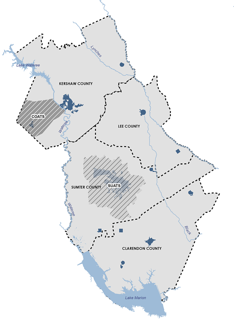
The Santee-Lynches transportation planning region encompasses all of Clarendon and Lee Counties and the non-urbanized portions of Kershaw and Sumter Counties. This planning area contains 10 municipalities and is home to over 223,000 people.
Transportation needs in the City of Sumter and Town of Elgin are addressed by the Sumter Urban Area Transportation Study (SUATS) and the Columbia Area Transportation Study (COATS), respectively because of the more urban nature of Sumter and western Kershaw County.
Existing Conditions
TRENDS
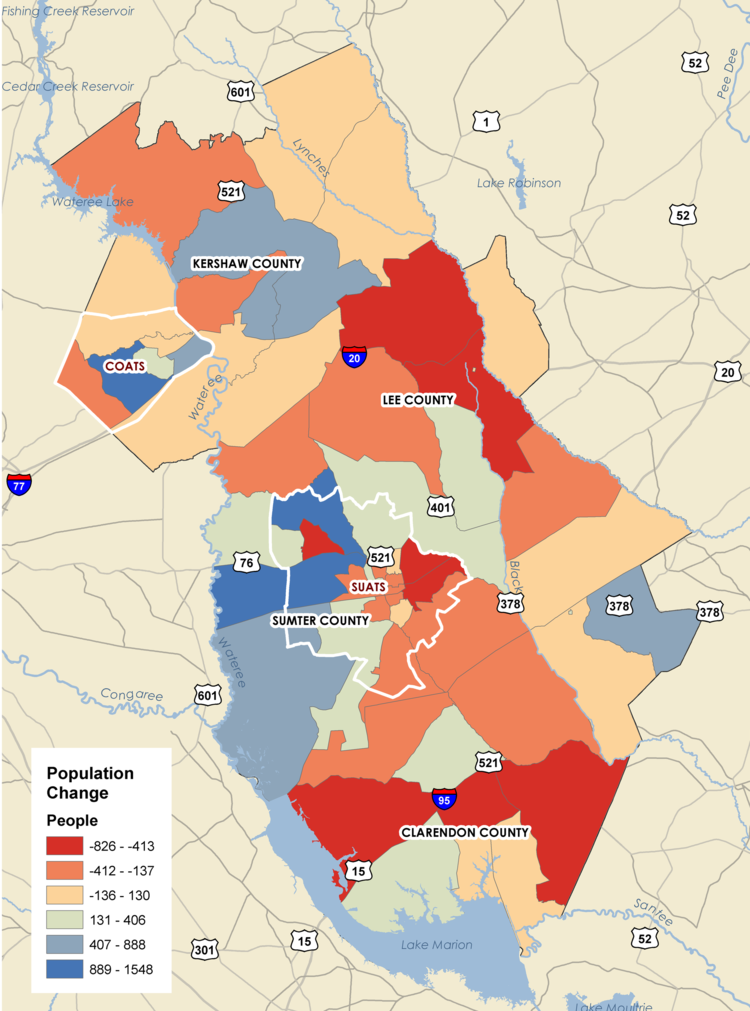
POPULATION GROWTH
The Santee-Lynches region grew by approximately 13,000 people between 2000 and 2017, with the majority of the growth occurring before 2010. That growth as been uneven throughout the region. Kershaw County has experienced dramatic growth, adding over 12,000 people to the population mostly in western Kershaw. Sumter and Clarendon Counties experienced steady population growth between 2000 and 2010, yet growth has stagnated since 2010. Meanwhile, Lee County saw significant population decline losing 3,000 people, almost 14% of its 2000 population.
AGING POPULATION
The population in the Santee-Lynches region is aging. The median age of residents in all of the counties has increased by between 4 to 6 years with the exception of Sumter County. The percent of the population over age 65 has also increased during the same period by over 4.0% in all the counties. This aging population will present some transportation challenges in the future as older individuals are often less mobile and face unique safety challenges as drivers.
ECONOMIC DEVELOPMENT
Context
The Santee-Lynches region has long been an agricultural hub. While agriculture remains an important segment of the economy, manufacturing and retail have become dominant employment sectors, and much of the anticipated growth in the four counties is tied to the establishment of major manufacturing operations and the growth of the of the Columbia metro area to the west. Currently, the City of Sumter, the largest city, serves as a focal point for economic and social activities. Camden serves as a secondary regional center, while Bishopville and Manning serve as trade centers within their respective counties. These are the areas with the greatest concentration of jobs.
The region also has many strategic transportation linkages within the state and beyond. Close proximity to Columbia affords easy access to both road and air transportation hubs, including the Columbia Metropolitan Airport (CAE). A short distance to the south, the Port of Charleston is one of the East Coast’s major seaports. Access to I-20 and I-95, provides easy ground transportation for both North-South and East-West travel. Both highways are key freight corridors.
Labor Force
 While the region's population has grown, the labor force (number of employed and unemployed people looking for work) and employed people are in decline. In 2007, the region had a labor force of 95,010 people, 88,563 of which were employed. In the following decade, the labor force and number of employed people declined as the recession impacted the area.
Even with economic recovery, the labor force has not returned to its 2007 figure. There are now only 92,081 people in the labor force, a decline of 3,000 people. There may be numerous causes behind the labor force decline including an aging workforce and various social factors. Total employment has also not recovered to pre-recession levels as there are approximately 1,000 fewer people employed in the region since 2007. As with population change, Lee County has been most affected by labor force changes, losing almost 2,000 people in their labor force and 1,500 employed people. These changes in the labor force are important in considering issues of congestion, road capacity, freight improvements, among others.
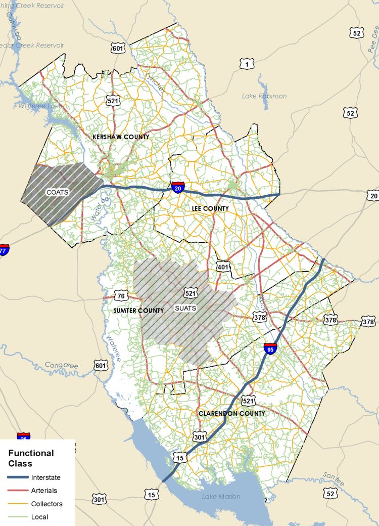
FUNCTIONAL CLASSIFICATION
Defined by the Federal Highway Administration (FHA), a roadway's functional classification designates the purpose of a roadway and the service it provides as part of the road network. There are four major functional classes of roads in the region.
Interstates - roads that provide the highest mobility and carry automobiles at the highest speeds for the longest distances
Arterials - roads that supplement interstates, connecting cities and town inside and outside the region. Arterials provide high mobility at moderate to fast speeds and provide some access to local properties.
Collectors - major and minor roads that connect local roads to arterials. They provide less mobility to drivers at lower speeds but connect people more to local land uses.
Locals - roads that provide limited mobility and are the primary access to residential areas, businesses, and other local areas. They have the lowest speeds and make up the majority of roads.
ROADWAYS
Of the over 5,900 miles of roadway in four counties that make up the entire Santee-Lynches region, 4,456 miles fall under Santee-Lynches transportation planning jurisdiction. 65% or 2,890 miles of roadway are owned by the state with the remaining roadway belonging to the counties or municipalities.
PAVEMENT QUALITY
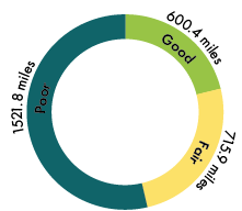 The 2016 Pavement Quality Index surveyed nearly 3,000 miles of road in the Santee-Lynches planning region with the pavement receiving a rating of Poor, Fair, or Good. These ratings generally describe the condition of pavement and the remaining service life (RSL) with poor pavement having an RSL of five years or less and good pavement having an RSL of ten years or more.
53.6% of roads in the planning jurisdiction have a Poor rating, 25.2% have a rating of Fair, and 21.2% have a Good rating.
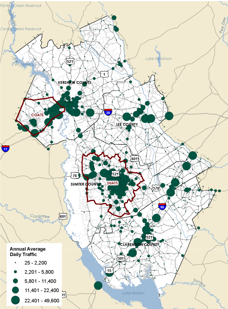
ANNUAL AVERAGE DAILY TRAFFIC
Annual Average Daily Traffic (AADT) indicates the traffic volumes for each roadway in 2016 as collected by the South Carolina Department of Transportation (SCDOT).
AADT is one measure to identify the most heavily traveled and least congested roadways in a region. In the Santee-Lynches planning jurisdiction, I-95 and I-20 are the most heavily traveled in the region because of their function as interstates. Over 30,000 vehicles travel on those interstates on any given day.
Other roads with high traffic volumes in the planning region include:
I-95 before Lake Marion
I-20 at US-521 outside Camden
US-1 between Camden and Lugoff
I-20 in Bishopville
SC-261 in Manning
US-15 in Bishopville
SAFETY
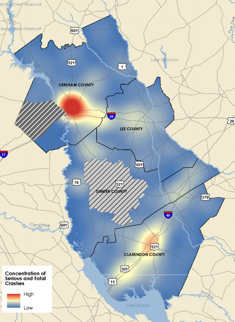
Between 2011 and 2016, there were 11,989 total crashes recorded in the Santee-Lynches planning jurisdiction. Of those crashes, 4% were serious or fatal crashes. The majority of these serious and fatal crashes occurred around Camden and to a lesser extent along I-95, near Manning. This map does not show crashes in the SUATS or COATS planning areas.
The following is a breakdown of the crashes by severity in the planning region over a five year period.
65% - no injury
25% - possible injury
6% - non-incapacitating injury
2% - incapacitating injury
2% - fatal
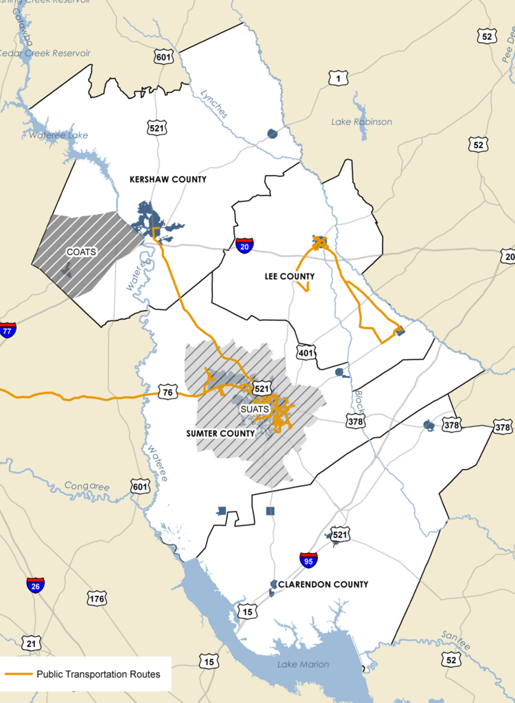
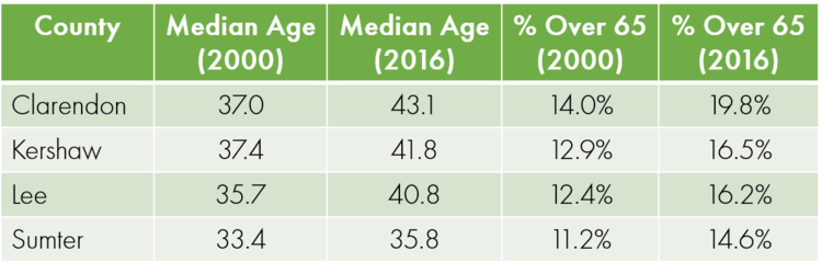
PUBLIC TRANSPORTATION
Santee-Wateree Regional Transportation Authority (SWRTA) operates several fixed-route bus routes in the Sumter metro area and in Lee County, as well as commuter routes to Camden and Columbia. SWRTA also offers paratransit services in throughout the counties, often in conjunction with other local agencies.
In addition to the local services, there are several long distance services that operate in the region including Greyhound with stops in Sumter and Camden, and Southeastern Stages, with a stop in Sumter. This map shows the location of local routes in the region.
SIDEWALKS
Each of the municipalities in the planning region has some sidewalk network, with some localities having more limited networks than others. In addition to the municipal sidewalk networks, there are a few rural crossroads in the region that also have some sidewalks: St. Charles in Lee County and Alcolu and New Zion in Clarendon County. Sidewalks that are on both sides of the road are highlighted in blue while sidewalks that are only on one side of the road are highlighted in orange in the maps below.